Barbara Opar and Barret Havens, column editors
Column written by Jamie Rogers, Assistant Director of Digital Collections at Florida International University and John Nemmers, Associate Chair, Special and Area Studies Collections at the University of Florida Smathers Libraries
During the last two decades digitization initiatives in libraries, museums, and archives worldwide have sprung up en masse. Today, as new digital collections are created, and older collections mature, questions about discovery and use become increasingly important. It is no longer enough to merely create digital archives as passive databases of content. The stewards of these digital archives are now looking at new ways for patrons to find and interact with collections. Trends in federal funding for digital projects also point to this paradigm shift.
Starting in 2012, the University of Florida (UF) and Florida International University (FIU) launched two very similar initiatives to provide new modes of access to existing collections, including spatial and temporal searching capabilities. Both of these projects, UF’s Unearthing St. Augustine’s Colonial Heritage, and FIU’s Coral Gables – Virtual History, were built upon existing local partnerships and a common software platform with the intent of engaging the local communities and serving a broad audience with cross-discipline content.
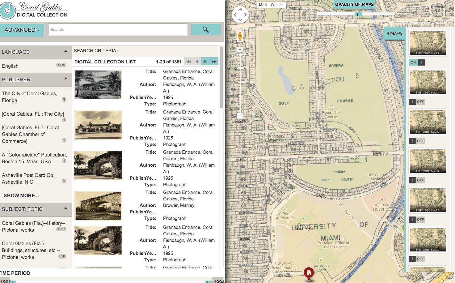
Coral Gables – Virtual History is a suite of digital library tools that allow patrons to discover the city through a collection of thousands of digital artifacts and virtual tours. Patrons may use a Google Maps interface to navigate to any point in the city at a selected time period (e.g. the Biltmore Hotel from the 1920s to 1940s), and experience the city as it was, through a wide variety of cultural and historical materials. The collection currently hosts over 10,000 digitized and rectified maps, architectural drawings, property parcels, photographs, documents, books, and ephemera. These materials have been spatially registered to their relevant locations and time. A series of historic maps have also been digitized and may be overlaid on a Google Maps interface. The transparency of the maps can be adjusted to see the changes in landscape that have taken place over time (http://maps.fiu.edu/cgm/cgmCollections.htm).
Coral Gables Virtual History – Users may search and browse with facets on the left side of the screen. On the right, a map displays points associated with the digitized materials. As users select a point on the map, the list on the left updates to display materials related to that location.
Coral Gables Virtual History – On the right side of the screen, users may select from a list of historic maps to overlay on the Google Map interface. Users may also adjust the transparency of the overlaid maps.
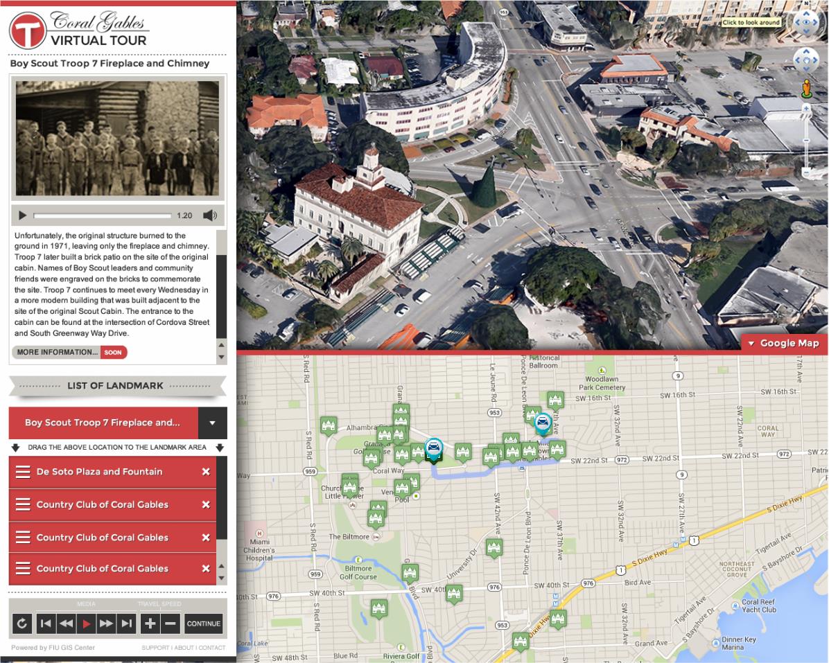
The second part of this project is a system that allows patrons to explore the landmarks of the city through a virtual tour, which includes an audio narration and 3D simulations providing the façade of historic buildings and landscape (http://maps.fiu.edu/cgm/cgmTour.html).
Coral Gables Virtual History – The virtual tour provides images and information about each landmark on the left side of the screen. Landmarks may be added to a queue to generate a tour of the city. When the tour is activated, an audio narration will play at each landmark while the tour route is traced on the map and 3D images of the landmarks are displayed in Google Earth.
Currently, Coral Gables – Virtual History is beginning the second round of funding and Phase II of a six-year cycle funded by the City of Coral Gables. During this phase, the team plans to expand system functionality to include bicycle and pedestrian routes for the virtual tour and crowdsourcing capabilities. Phase II will also include an animated 3D display of development of the city over time and the incorporation of property records and drawings in the collection. All of the new tools will be created with a responsive, mobile friendly design, with the exception of the 3D display.
This project was made possible through a number of partnerships including the FIU Digital Collections Center, FIU Geographic Information Systems Department, FIU Department of Landscape Architecture, the UF Digital Collections and an Advisory Board consisting of museum professionals, archivists, library professionals, GIS experts, architects, and city officials.
The Unearthing St. Augustine’s Colonial Heritage (http://ufdc.ufl.edu/usach) project at UF is a 3-year project (2012-15) to create an interactive digital collection of over 10,000 architectural drawings, photographs, maps and documents relating to colonial St. Augustine. With funding from the National Endowment for the Humanities, the project will be completed in summer 2015 coinciding with the 450th anniversary of the founding of the city. As the oldest continually inhabited colonial settlement in the continental U.S., St. Augustine includes dozens of buildings and sites dating from the colonial era.
For several years, UF has been scanning its numerous holdings relating to the city’s architectural heritage and making these resources available in the UF Digital Collections (http://ufdc.ufl.edu). The current project brings together primary resources in history, architecture, historic preservation, archaeology, anthropology and geography, dating from the 16th century to the present. In addition to the UF George A. Smathers Libraries, partners include the City of St. Augustine Archaeology program, the St. Augustine Historical Society and FIU, which is providing programming and systems support for the project. The project advisory board includes archivists, historians, librarians, GIS experts, architects, archaeologists and city officials.
As with the Coral Gables project, the St. Augustine website will provide searching and browsing functionality in a Google Maps interface, with the ability to select a specific structure and view all associated digital objects. The site also will allow users to limit search results to specific time periods (e.g., Spanish or British Colonial). Historic maps will be overlaid on the Google map, and by adjusting the transparency researchers will be able to compare features over time.
Future activities will focus on St. Augustine’s non-colonial periods (e.g., Gilded Age development), using crowdsourcing to generate descriptive content or geospatial metadata, and historical tour features. Both UF and FIU will continue to advance these digital projects and explore improved ways for researchers to discover and interact with resources. These projects can serve as models for other cities or regions interested in access systems with geographical and/or temporal technologies.

 Study Architecture
  ProPEL


